|
California Views:
|


|
|
|
California Views:
|
|
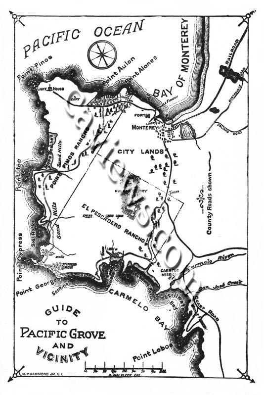 R. P. Hammond, Jr. C.E. |
Monterey and central California MapsCirca 1879 We have a collection of early map reproduction of Monterey County. Early California and Monterey regional history. Monterey County map by S. W. Smith, County surveyor 1869 The Monterey area includes coastal areas from Watsonville, Monterey, Pacific Grove, Pebble Beach, Carmel, Big Sur, Fort Ord, Salinas and central California. The official 1898 Map of Monterey County by Lou G. Hare, Monterey County surveyor from the early 1890's to 1914. To obtain permission to use any photographs please contact Mr. Pat Hathaway @ 831-373-3811 We have over 35,000 historical California images listed in our database and can provide a computer generated list by subject, place, date, photographer and format or any combination of the above for a small fee. Holdings: over 28,000 Photos of Monterey County listed in our database. |
|
Prints are available from 11 x14 - 40x60 inches. All images are also available for editorial downloads and one-time editorial use. Please keep checking back as we will be adding more galleries |
|
California Views home main menu
Go to Point Pinos Lighthouse Go to Casa Castro, Monterey, 1880 Go to Hotel Del Monte, 1880 Go to Chinese in the Monterey Bay area 1890 Go to Lighthouse Avenue, Pacific Grove, 1936 Go to Presidio of Monterey Photo Collection Transportation Photo Gallery |
Go to Carmel Mission, 1884
Go to Point Lobos, 1880 Go to Monterey street scene 1887 Go to 17 Mile Drive, Pebble Beach Go to Southern Pacific Del Monte Limited 4-4-0 Go to Carmel River Beach, 1948 and 2005 Go to Watsonville, Circa 1926 |
|
Copyright©2019 California Views Historical Photo Collection To obtain permission to use any photographs please contact Pat Hathaway Dedicated to the preservation of our California photographic heritage |
|
California Views Photo Archives Monterey, California 93940-2702 Phone (831) 373-3811 By Appointment Only Pacific time Greenwich Mean Time -8 |
|
|
|
|